News

1. New Technology and Service, Innovation

Drone geophysical surveys involve using unmanned aerial vehicles (UAVs), commonly known as drones, to collect geophysical data over a specified area. These drones are equipped with various sensors capable of measuring different physical properties of the Earth’s surface and subsurface. The data collected from drone surveys can provide valuable insights into geological features, environmental conditions, and resource potential.

Some common types of geophysical surveys conducted using drones include:

  1. Magnetic surveys: Drones equipped with magnetometers are used to measure variations in the Earth’s magnetic field. These variations can indicate the presence of subsurface geological structures, such as mineral deposits or faults.
  2. Electromagnetic surveys: Electromagnetic sensors mounted on drones can measure variations in the conductivity of the Earth’s subsurface. This information is useful for mapping groundwater resources, identifying geological formations, and locating buried objects or utilities.
  3. Thermal surveys: Drones equipped with thermal cameras can capture infrared images of the Earth’s surface, which can reveal thermal anomalies associated with geological features, hydrothermal systems, or environmental changes.
  4. Hyperspectral surveys: Hyperspectral sensors mounted on drones can capture data across a wide range of wavelengths, allowing for detailed analysis of surface materials and vegetation cover. This information is valuable for mineral exploration, environmental monitoring, and agricultural applications.

Drone geophysical surveys offer several advantages over traditional ground-based surveys, including rapid data collection, high spatial resolution, and accessibility to remote or inaccessible areas. Additionally, drones can operate at low altitudes, providing detailed data coverage and reducing the influence of environmental noise.

Overall, drone geophysical surveys are becoming increasingly popular in various industries, including mining, environmental monitoring, infrastructure inspection, and scientific research, due to their efficiency, cost-effectiveness, and versatility.

Matrice 350 RTK Worry-Free Basic Combo?

The Matrice 350 RTK Worry-Free Basic Combo is a comprehensive package offered by DJI, a leading manufacturer of drones and aerial imaging technology. Here’s a breakdown of what it typically includes:

  1. Matrice 300 RTK (M300 RTK): The Matrice 300 RTK is a powerful commercial drone designed for industrial applications. It features advanced flight capabilities, high payload capacity, and a long flight time.
  2. Remote Controller: The package includes a dedicated remote controller with a built-in screen for convenient operation of the drone.
  3. DJI Smart Controller Enterprise: This is a ruggedized controller designed specifically for enterprise applications. It provides a high-quality display and integrates seamlessly with DJI’s enterprise drones.
  4. DJI Zenmuse H20 Series Payloads: The Zenmuse H20 series payloads are integrated camera systems specifically designed for the Matrice 300 RTK. These payloads typically include a high-resolution camera, a zoom camera, a thermal imaging camera, and a laser rangefinder.
  5. DJI Care Refresh: DJI Care Refresh is a service plan offered by DJI that provides comprehensive coverage and support for your drone. It typically covers accidental damage, water damage, and other issues.
  6. Accessories: The combo may also include various accessories such as extra batteries, propellers, chargers, and carrying cases to ensure you have everything you need for your aerial missions.
Overall, the Matrice 350 RTK Worry-Free Basic Combo is designed to provide everything you need to start using the Matrice 300 RTK drone for commercial or industrial applications with peace of mind, thanks to the included DJI Care Refresh service plan.

2. Water Detector and GeoSeeker Mini

Like the water detector OKM GeooSeeker, the GeoSeeker Mini utilizes a geoelectrical measurement procedure based on Schlumberger. The water detector – that can also be used to detect underground cavities – determines the soil resistivity. Based on that apparent resistivity of the ground the detector is able to detect underground water resources like fresh water, drinking water, water-bearing gravel and groundwater level.

Based on the fact that underground water has a very good conductivity, you can conclude that very bad conductivity is a hint for hidden cavities like caves, tunnels, chambers and underground rooms. Thus, the geophysical detector GeoSeeker Mini can be deployed as water finder and cavity detector at the same time.

Operating the water and cavity detector GeoSeeker Mini

The water detector GeoSeeker Mini is operated via touchscreen. Select the measurement depth as well as the amount of scanning points and simply follow the graphical instructions. Due to easy-to-understand images and icons, the GeoSeeker Mini is multilingual by using pure picture language.

During the measurement the electrodes have to be replaced several times to measure the ground resistivity at certain places. All instructions can be read from the color display, where the results are presented after each single scan. At the very end of a measurement the final result is shown as a graphical 2D scan image.

Data visualization of water resources and cavity

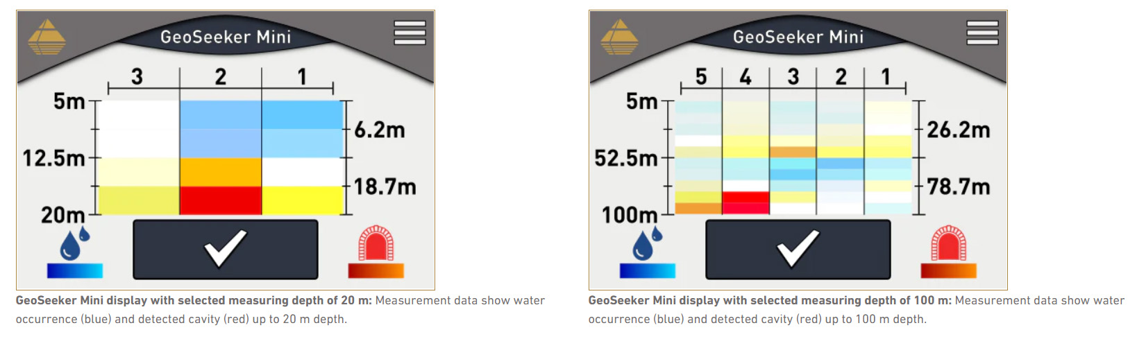
After finishing a geoelectrical measurement, the final result is calculated to generate a representative 2D scan image of the underground resistivity. With the pictograms in the lower display area, users can read directly the diagram: The colors in the scheme indicate water deposits (blue with water drops) and/or detected cavities (red with tunnel symbol).

Geoelectrical applications with GeoSeeker Mini

Water Detection / Well Building

Geotechnical Engineering

Cavity Detection

Agriculture

Archaeology

OKM Search Services