
Геофизик, инженер геотехникийн судалгааны ажил үйлчилгээ (01)
ОКМ ГеоСэкэр Миний Детектор нь уст цэг тогтоох геофизикийн судалгааны ажлын багаж тоног төхөөрөмж бөгөөд Шлюмбержийн арга аргачлал дээр суурилсан, геоэлектрик хэмжилтийн процедурыг ашиглан газрын гүнд <100 метр хүртэлх хөрсний болон чулуулгийн үе давхарга дахь хувийн цахилгаан эсэргүүцэл, цэвэр болон ундны ус, ус чийг агуулсан элс, хайрга, цэвдэг, нүх агуу зэргийг 2 хэмжээстээр зүсэлтийн шугамчлалын дагуу тогтоох бүрэн боломжтой Герман улсад үйлдвэрлэгдсэн орчин үеийн инновацад бүрэн нэвтэрсэн дэвшилтэд техник технологи юм.
Ажлын цар хүрээ:
- Геологи, уул уурхай, барилга, зам гүүр, дэд бүтэц
- Хүнс, хөдөө аж ахуй, хөрс судлал, иргэний инженерчлэл
- Археологи, эртний эдлэл, судлал
Ороген Төрлийн Алтны Хүдэржилт ба Геофизикийн Хайгуулын Ажлын Шийдэл, Цахилгаан Хайгуулын (DCIP2D) Тоон Өгөгдөл Боловсруулах, Загварчлах Үйлчилгээ (02)
Ороген Төрлийн Алтны Хүдэржилт ба Орд
Ороген төрлийн алтны хүдэржилт бол гидротермаль гаралтай ашигт малтмалын ордын нэгэн төрөл юм. Хүн төрөлхтний түүхийн туршид олж авсан алтны 75 гаруй хувь нь Ороген төрлийн алтны ордын ангилалд багтдаг байна. Энэ төрлийн орд нь тектоникийн шахалт, хувирал, хагарал-зөрчлийн бүсээр халуун шингэн (hydrothermal fluid) хөдөлж алт тунадасжих үед үүсдэг. Энгийнээр өгүүлбэл: гүнээс ирсэн халуун шингэн + хагарал + даралт бууралт = алтны хүдэржилт
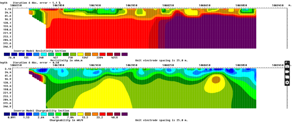
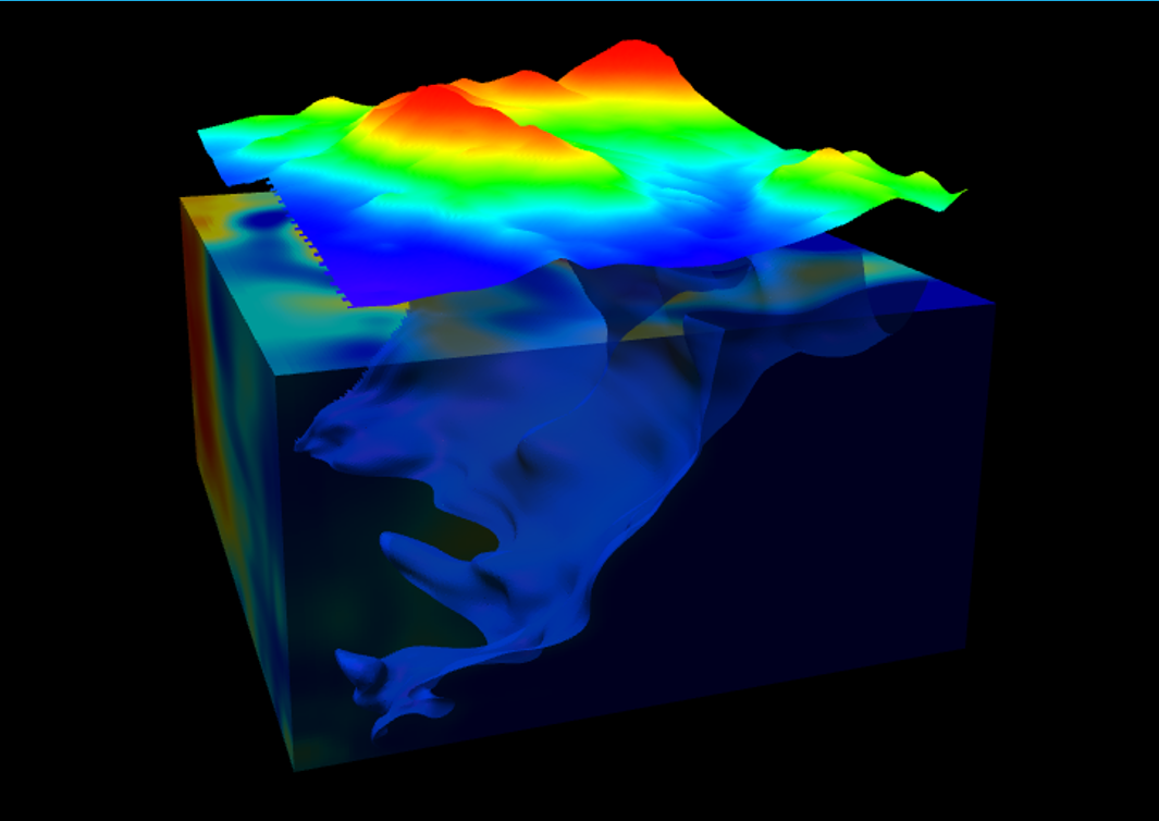
Эсэргүүцлийн 3 хэмжээст инверсийн урвуу хувиргалт ба загварчлалын тухайд
3D surveys are more time-consuming and expensive to carry out, nut could be useful for very complex geological situations. The reduce costs to the user, RES3DINV is sold as a combined package with RES2DINV which costs only about 25% more than the RES2DINV program alone. It is probably more than an order of magnitude faster than some other commercially available 3D inversion software.
RES2DINV is the 2D resistivity and IP inversion software, besides normal land surface surveys, it also supports underwater and cross-borehole surveys. In addition to the standard Wenner (alpha, beta, gamma), Wenner-Schlumberger, pole-pole, pole-dipole, inline dipole-dipole, equatorial dipole-dipole arrays; it also supports non-conventional electrode arrangements. RES3DINV is the 3D resistivity and IP inversion software, and it is probably the first widely available commercial software of this type.
- Supports dipole-dipole, pole-dipole, pole-dpole
- Supports gradient and surface to borehole surveys
- User defined starting model and inversion parameters
Тоон өгөгдөл ба дүн шинжилгээ
3D Model Display and editing with associated 3D data display to assist model design
Cross/plan section displays of 3D inversions
Pseudo-section, depth images, multi-parameter data grids, sliced depth models
Extensive plotting capabilities, data referencing to CP, Tx or Rx
Тоон өгөгдөл бэлтгэх
- Time domain IP, GDD, Zonge, IRIS, Scintrex formats or as an ASCII text format
- Resistivity data with phase if available Zonge, Syscal, Generic ASCII text files
Манай үйлчилгээний 95% нь чанар, мэргэжлийн ур чадварт суурилдаг.
Геофизикийн зөвлөх үйлчилгээ (03)
Геофизикийн хайгуул, судалгаа, тоон өгөгдөл боловсруулалтад, дэлхийд геологи, уул уурхайгаар тэргүүлэгч улс орнуудын хэрэглэдэг багаж тоног төхөөрөмжүүдийг, мөн программ хангамжуудыг ашигладаг. Геологи-геофизикийн 1D болон 2D, 3D хэмжээст инверсийн урвуу хувиргалт ба загварчлалын ажлуудыг олон улсын стандартын дагуу, тэдгээрийн шаардлагад бүрэн нийцэхүйц чанарын өндөр түвшинд түргэн шуурхай хийж гүйцэтгэж, захиалагч нарт үр дүнгийн мэдээллүүдийг үнэн зөвөөр хүлээлгэн өгч байна.