
Certified Geophysicist Professionals
The survey results would vary depending on the objectives of the exploration, but they could include maps of subsurface geological structures, estimates of resource quantities and qualities, identification of potential hazards, or other relevant information. These results are crucial for decision-making in various industries including mining, oil and gas exploration, environmental assessment, and civil engineering.
Geophysical Exploration Works & Surveys
A Geophysical exploration plan typically outlines the objectives, methods, equipment, and procedures to be used in conducting a survey to investigate subsurface geological structures or resources.
The plan might include:
- Objectives: Clearly stating the purpose of the survey, whether it’s to locate mineral deposits, map underground water resources, identify geological hazards, or for any other specific purpose.
- Survey Area: Defining the geographical area to be surveyed. This could be a specific site or a larger region depending on the scope of the project.
- Geophysical Methods: Describing the geophysical techniques to be employed such as seismic surveys, electromagnetic surveys, gravity surveys, magnetic surveys, ground-penetrating radar, etc. Each method has its own advantages and limitations, and the choice depends on the geological conditions and the objectives of the survey.
- Survey Equipment: Listing the equipment required for data acquisition, processing, and interpretation. This could include instruments like seismographs, magnetometers, gravimeters, GPS units, computers with specialized software, etc.
- Survey Design: Planning the layout of survey lines or grids, spacing of measurement points, and other parameters to ensure adequate coverage and resolution of the target area.
- Field Procedures: Detailing how the survey will be conducted in the field, including safety protocols, data collection protocols, quality control measures, and environmental considerations.
- Data Processing and Interpretation: Outlining the procedures for processing raw data into interpretable results, and the methods for interpreting these results to derive geological or resource-related information.
- Reporting: Specifying the format and content of the final report, which typically includes background information, survey methodology, data analysis, interpretations, conclusions, and recommendations.
Geophysical Exploration – Data Processing – Modelling & Inversing – Consulting Services
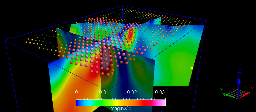
Magnetic & Gravity 3D modelling, processing services is typically refers to the computational techniques used in geophysics to analyze and interpret data collected from magnetic and gravity surveys. These surveys are commonly conducted in fields such as mineral exploration, oil and gas exploration, environmental studies, and archaeology.
Here’s a breakdown of what magnetic and gravity 3D modelling processing involves:
- Data Collection: Magnetic and gravity data are collected using specialized instruments like magnetometers and gravimeters. These instruments measure the variations in the Earth’s magnetic and gravitational fields, respectively, which can be influenced by subsurface geological structures and materials.
- Data Processing: Raw data collected from the surveys undergo various processing steps to remove noise, correct for instrument drift, and enhance the signal-to-noise ratio. This processing may involve filtering, leveling, and other digital signal processing techniques.
- 3D Modelling: Once the processed data is ready, it is used to construct 3D models of subsurface geological features. This involves interpolating the data points to create a continuous representation of the subsurface properties, such as the distribution of rock types, faults, and mineral deposits.
- Inversion: Inversion algorithms are applied to the processed data to estimate the subsurface properties from the observed magnetic and gravity measurements. Inversion methods aim to find the most probable distribution of geological features that could explain the observed data.
- Interpretation: Geophysicists and geologists interpret the results of the 3D modelling to understand the subsurface geology and identify potential targets for further exploration or investigation. This may involve identifying mineral deposits, mapping geological structures, or delineating areas of interest for resource extraction.
Overall, magnetic and gravity 3D modelling processing plays a crucial role in understanding the subsurface geology of an area and informing decision-making in various industries reliant on Earth’s resources and environmental studies. Geophysical 3D modelling is a computational technique used to simulate and visualize the subsurface structures and properties of the Earth. It involves integrating various geophysical data sets, such as seismic, gravity, magnetic, and electrical data, to create a comprehensive representation of the Earth’s subsurface in three dimensions.